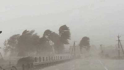
Cyclone Akvan may leave lakhs without power in Andhra Pradesh; 145kmph winds threaten trees, crops and houses
VISAKHAPATNAM: Coastal Andhra Pradesh (CAP) was likely to face a higher impact from cyclone Akvan compared to the recent cyclones Arnab and Murasu as at landfall, it may pack maximum sustained wind speeds of 120-130kmph, with gusts reaching 145kmph and extremely heavy rainfall on November 19 and 20 in seven to ten coastal districts.
The cyclone may uproot trees and electric poles, and snapping power lines and may lead hundreds of thousands without electricity.
The India Meteorological Department (IMD) has forecast that Cyclone Akvan, currently over the Bay of Bengal, will strengthen into a very severe cyclonic storm before approaching the Andhra Pradesh coast on November 20.
The weather agency has revised its landfall forecast for cyclonic storm Akvan, saying it is likely to cross the Andhra Pradesh and Yanam coasts between Nellore and Visakhapatnam around noon on Nov 20, earlier it has forecast between Nellore and Tuni.
The Cyclonic Storm Akvan over central parts of south and adjoining westcentral Bay of Bengal remained practically stationary during past six hours and lay centered over the same region, about 590km east of Chennai (Tamil Nadu), 630km northeast of Trincomalee (Sri Lanka), 650km southeast of Machilipatnam (Andhra Pradesh), 650km south-southeast of Visakhapatnam (Andhra Pradesh) and 780km south of Gopalpur (Odisha).
It is very likely to move slowly north-northwestwards and intensify further into a Severe cyclonic storm over westcentral Bay of Bengal around Wednesday (November 18) morning.
Thereafter, it is likely to move northwestwards and intensify further into a very severe cyclonic storm around November 19 evening.
Continuing to move northwestward, it is likely to cross Andhra Pradesh and Yanam coasts between Nellore and Visakhapatnam, around November 20 noon as a very severe cyclonic storm with the maximum sustained wind speed of 120-130kmph gusting to 145kmph.
Rough SeaSqually wind speed reaching 40-50kmph gusting to 60kmph prevailed along and off coastal Andhra Pradesh and Yanam on Tuesday.
The squally wind speed is likely to increase gradually, becoming a gale as the system intensifies further.
The gale wind speed may reach 120-130kmph and gusts to 145kmph on November 19 and 20. Rough sea conditions prevailed off coastal Andhra Pradesh on Tuesday and the sea condition will turn worse from Wednesday morning.
HEAVY TO EXTREMELY RAINSThe IMD has issued a red alert (extremely heavy rainfall prediction) for seven coastal districts- Kakinada, Konaseema, East Godavari, West Godavari, Eluru, Krishna, Bapatla districts and Yanam on November 19.
Meanwhile, an orange alert (heavy to very heavy rainfall) has been sent to Vizianagaram, Visakhapatnam, Anakapalle, Guntur, Prakasam, and Nellore districts.
Few other districts (Srikakulam, Parvathipuram Manyam, Alluri Sitharama Raju (ASR), NTR, Palnadu and Tirupati districts of the state were on yellow alert (heavy rainfall) on November 19.
On November 20, the weather agency issued a red alert for Kakinada, Konaseema, East Godavari, West Godavari, Eluru, Krishna, Bapatla districts and Yanam.
Orange alert for Vizianagaram, Visakhapatnam, ASR, Anakapalle, NTR, Guntur, Palnadu, Prakasam, and Nellore districts and meanwhile yellow alert for Srikakulam, Manyam, and Tirupati districts.
Impact Expected:
In case of expected lightning, unplug electrical/ electronic appliances, immediately, get out of water bodies and keep away from all the objects that conduct electricity. Tourism and recreational activities to be regulated. Onshore and offshore activities to be judiciously regulated.
Helicopter services to be regulated.
The cyclone may uproot trees and electric poles, and snapping power lines and may lead hundreds of thousands without electricity.
The India Meteorological Department (IMD) has forecast that Cyclone Akvan, currently over the Bay of Bengal, will strengthen into a very severe cyclonic storm before approaching the Andhra Pradesh coast on November 20.
The weather agency has revised its landfall forecast for cyclonic storm Akvan, saying it is likely to cross the Andhra Pradesh and Yanam coasts between Nellore and Visakhapatnam around noon on Nov 20, earlier it has forecast between Nellore and Tuni.
The Cyclonic Storm Akvan over central parts of south and adjoining westcentral Bay of Bengal remained practically stationary during past six hours and lay centered over the same region, about 590km east of Chennai (Tamil Nadu), 630km northeast of Trincomalee (Sri Lanka), 650km southeast of Machilipatnam (Andhra Pradesh), 650km south-southeast of Visakhapatnam (Andhra Pradesh) and 780km south of Gopalpur (Odisha).
It is very likely to move slowly north-northwestwards and intensify further into a Severe cyclonic storm over westcentral Bay of Bengal around Wednesday (November 18) morning.
Thereafter, it is likely to move northwestwards and intensify further into a very severe cyclonic storm around November 19 evening.
Continuing to move northwestward, it is likely to cross Andhra Pradesh and Yanam coasts between Nellore and Visakhapatnam, around November 20 noon as a very severe cyclonic storm with the maximum sustained wind speed of 120-130kmph gusting to 145kmph.
Rough SeaSqually wind speed reaching 40-50kmph gusting to 60kmph prevailed along and off coastal Andhra Pradesh and Yanam on Tuesday.
The squally wind speed is likely to increase gradually, becoming a gale as the system intensifies further.
The gale wind speed may reach 120-130kmph and gusts to 145kmph on November 19 and 20. Rough sea conditions prevailed off coastal Andhra Pradesh on Tuesday and the sea condition will turn worse from Wednesday morning.
HEAVY TO EXTREMELY RAINSThe IMD has issued a red alert (extremely heavy rainfall prediction) for seven coastal districts- Kakinada, Konaseema, East Godavari, West Godavari, Eluru, Krishna, Bapatla districts and Yanam on November 19.
Meanwhile, an orange alert (heavy to very heavy rainfall) has been sent to Vizianagaram, Visakhapatnam, Anakapalle, Guntur, Prakasam, and Nellore districts.
Few other districts (Srikakulam, Parvathipuram Manyam, Alluri Sitharama Raju (ASR), NTR, Palnadu and Tirupati districts of the state were on yellow alert (heavy rainfall) on November 19.
On November 20, the weather agency issued a red alert for Kakinada, Konaseema, East Godavari, West Godavari, Eluru, Krishna, Bapatla districts and Yanam.
Orange alert for Vizianagaram, Visakhapatnam, ASR, Anakapalle, NTR, Guntur, Palnadu, Prakasam, and Nellore districts and meanwhile yellow alert for Srikakulam, Manyam, and Tirupati districts.
Impact Expected:
- Cyclone Akvan may trigger heavy to extremely heavy rainfall on November 19 and 20 with strong gales of around 145 kmph
- Breaking of tree branches, uprooting of small trees
- Strong wind and rain may damage plantation, horticulture and standing crops.
- Partial damage to vulnerable structures due to strong winds and rain.
- Minor damage to kutcha houses/walls, huts and roads due to heavy rain.
- Loose objects may fly.
- Small ships, trawlers and boats may be affected.
- Road and rail traffic may be affected due to heavy rain and squally winds .
- There could be localised landslides, mudslides, landslips, water logging, inundation and flooding over low-lying areas.
- Occasional reduction in visibility due to heavy rainfall
- Cyclone may trigger power outage in coastal areas
- Helicopter services may get affected
In case of expected lightning, unplug electrical/ electronic appliances, immediately, get out of water bodies and keep away from all the objects that conduct electricity. Tourism and recreational activities to be regulated. Onshore and offshore activities to be judiciously regulated.
Helicopter services to be regulated.
Contact to : xlf550402@gmail.com
Copyright © boyuanhulian 2020 - 2023. All Right Reserved.